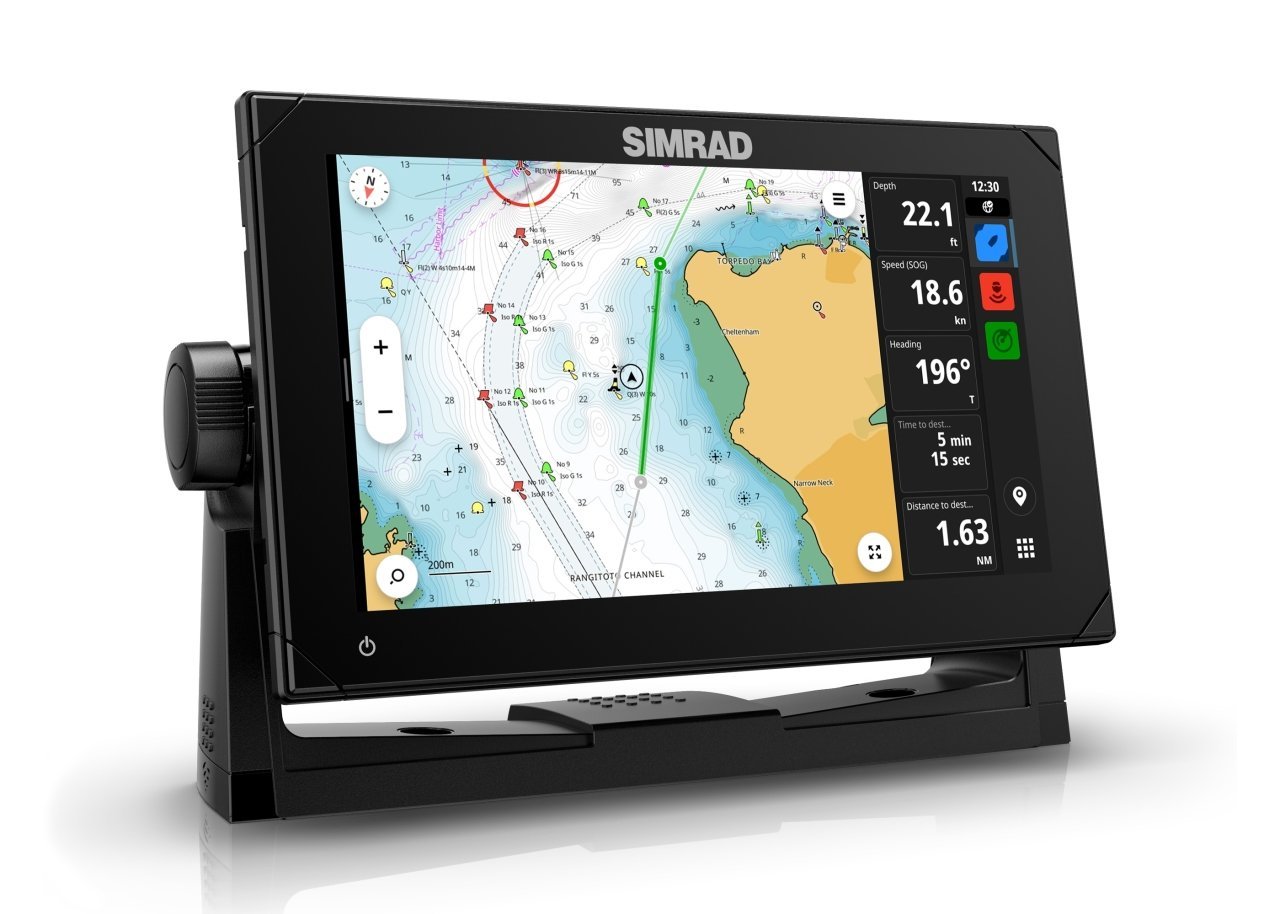
NSX™ 3009 Gps/Radar/Sonar Wifi Led Ekran (Transducersiz)
Marka
Stok Kodu
000-15219-001
Garanti Süresi
24 Ay
Fiyat
1.908,00 EUR + KDV
Havale
86.134,75 TL
(%5,00 havale indirimi)
9.345,62 TL den başlayan taksitlerle!!
%10
90.668,16 TL
100.742,40 TL
Simrad NSX™ 3009, No Transducer
Take your experience to a whole new level with the Simrad® NSX™ smart chartplotter and fishfinder. With an innovative, modern interface featuring powerful navigation capability with C-MAP® DISCOVER X charts, you’ll see everything like never before, our IPS touch screens capturing every detail. The NSX comes fully equipped with integrated Sonar, Radar and Autopilot systems, and with our handy Setup Wizard tool you’ll be up and running in no time. All you need to do now is choose your next on-the-water adventure.
NSX™ Smart Chartplotter and Fishfinder
Take your experience to a whole new level!
With an innovative, modern interface featuring powerful navigation capability with C-MAP® support, you’ll see everything like never before. The NSX features integrated Sonar, full Radar and Autopilot systems compatibility, and with our handy Setup Wizard tool, you’ll be up and running in no time. All you need to do now is choose your next on-the-water adventure.
A New, Intuitive Touch Screen Experience
Experience modern simplicity in rich detail. NSX pairs a clean and straightforward interface with high-definition visuals to deliver a whole new experience. Easily access and use all NSX features, including smart drag-and-drop screen customization, fully editable instruments bar and enhanced day and night modes. Get crystal clear views of chart detail, structure and bottom contours with the vibrant SolarMAX™ IPS touch screen. The high definition display is viewable from any angle, in direct sunlight, and through polarised lenses with complete touch screen operation.
Bring Navigation to Life with NSX
See map details in a new way. This includes support for next-generation C-MAP® DISCOVER X™ and REVEAL X™ marine-optimized charts developed for NSX, featuring a fresh, intuitive chart presentation and daily updates.
C-MAP charts include full-featured Vector Charts with Custom Depth Shading and High Resolution Bathymetry showing accurate contour lines down to a 1-foot level of detail. You can improve planning and route plotting with Tides and Currents projections and our fastest ever Autorouting. Plus, there’s a new Map Inspection feature with one-touch access to information on locations, POIs, tides, channels and more.
The Simrad® Companion App acts like an extension of your NSX with the same chart experiences and all your chart data at your fingertips, on or off the water. The app lets you plan trips, review Tracks and plot Waypoints on your App and sync directly to your NSX.
Full Suite of Simrad® Technology at Your Fingertips
NSX opens up a world of possibilities. Expand your system with powerful Simrad® Sonar, Autopilot and Radar technologies.
Get high resolution images below and to the sides of your vessel with Active Imaging™ featuring CHIRP sonar, SideScan/DownScan Imaging™ and FishReveal™. Search even greater depths with a wide range of compatible 1kW transducers.
Known for its legendary performance, Simrad® Autopilots free you up to enjoy all of your activities. Whether trawling for game fish or planning your next destination, we’ve got you covered. Available for outboard and inboard engines, our 'extra pair of hands' helps run patterns and routes, navigate to waypoints, and stay on course.
You can also identify hazards immediately. With our award-winning pulse compression HALO® Dome Radars, you can see near and far simultaneously (up to 42nm) with ultra-fast updates every second. Be ready instantly with low-power standby mode, and highlight targets using custom modes such as harbour, offshore and weather.
Simple to Set Up, Easy to Manage
With everything from a Setup Wizard to Simrad® App integration, simple sonar setup and hints to assist you when you need it, NSX makes life on the water easier than ever before.
The Setup Wizard helps with step-by-step instructions to get you up and running quickly, while the Simrad® App offers a whole host of added extras. These include hassle-free software updates, on and off the water trip planning, a streamlined chart display that looks the same across all platforms, plus easy transfer of all data, including routes and waypoints.
But that’s not all. Sonar hints offer guidance on what’s happening during settings adjustments and sonar device setup gives you easy-to-understand prompts for each step of the process – you’ll be up and running in no time. All you need to do now is choose your next adventure.
Key Features
- Features a marine-optimized C-MAP® DISCOVER™ X chart with a fresh, intuitive chart presentation and daily updates – plus support for C-MAP REVEAL™ X charts
- High definition IPS touch screen with extreme viewing angles, even viewable through polarized lenses
- Support for high resolution views of fish and structure with Active Imaging™ featuring CHIRP, SideScan and DownScan Imaging™, plus 1kW transducer capability to reach greater depths
- Setup Wizard to get you up and running quickly, plus simpler sonar setup
- Full integration with capability to expand system with Simrad® sonar, autopilot, radar, and more
- Faster Autorouting with seamless accessibility
- See near and far simultaneously (up to 42nm), with HALO® Radar support and get ultra-fast updates every second
- Stay on course with full Simrad® autopilot integration
- Modern and straightforward interface
- Simrad® App integration – keep your chart data at your fingertips, both on and off the water
- Third-party app integration
- Wireless connectivity, plus full Ethernet and NMEA 2000® networking capability
- IP Video Support
Specifications
- Screen Brightness
- >1200 nits
- SD Card Storage
- 1 MicroSD slot, USB port for external drive
- Ethernet Ports
- 1 port (5-pin connector)
- NMEA 2000 Connectivity
- 1 x NMEA 2000 Micro-C port, 1 LEN
- Weight
- 1.2 kg (2.6 lbs)
- Correction
- 10 Hz high speed update (internal)WASS, MSAS, EGNOS, GLONASS
- Shock Vibration
- 100,000 cycles of 20 G
- Update rate
- 10Hz
- Supply Voltage
- 12 V DC (10 - 17 V DC min - max)
- Display Resolution
- 1280 x 720 px
- Operating Temperature Range
- -15°C to 55°C (5°F to 131°F)
- Power Consumption max
- 18.8 W (1360 mA at 13.8 V)
- Warranty Period
- 2 Years
- Storage Temperature Range
- -20°C to 60°C (-4°F to 140°F)
- GPS Receiver Channels
- 32 Channels
- Recommended Fuse Rating
- 3A
- Compass Safe
- 50 cm (1.7 ft)
- Waypoints, Routes, Tracks
- 6000 waypoints, 500 Routes with 100 max route points, 50 tracks with upto 12,000 track points.
- Viewing Angles
- 85° (top, bottom, left, and right)
- Display Size
- 9 inches
- Bluetooth
- Bluetooth 4.0 with support for Bluetooth Classic
- Mounting Type
- Bracket (supplied), panel mount or flush mount
- Charts supported
- C-MAP Discover™ X, C-MAP Reveal™ X
- Charts Supported
- C-MAP Tile (CMT) Discover X C-MAP Tile (CMT) Reveal X
- Cartography included
- Discover X chart card of North America
- Languages
- English(US), English(UK), Danish, German, Spanish, Finnish, French, Greek, Italian, Dutch, Norwegian, Portuguese (Brazil), Portuguese (Portugal) Swedish
- Radar compatibility
- Halo Dome radars, Halo open array radars
- Position Accuracy
- Horizontal Accuracy 3 m (9.8 ft)
- Humidity
- IEC 60945 Damp heat 66°C (150°F) at 95% relative (18 hr)
- Connectivity Wi Fi
- IEEE 802.11b/g/n
- GPS
- Internal, 10Hz, WASS, MSAS, EGNOS
- Video
- Ip Camera support
- Waterproofrating
- IPx6 and IPx7
- Interface
- Multi-touch screen
- Weather
- No
- [ Missing text '/product/specs/J1939 Connectivity' for ' English ( United States)']
- No
- PC Connectivity
- No
- Sonar Compatibility
- One 9 pin Xsonic 1 kW Sonar port. Single channel CHIRP, 50/200 khz, HDI, Active Imaging
- AIS
- Receive AIS data over NMEA 2000
- N2K PG Ns
- Receive only59392 ISO Acknowledgement59904 ISO Request60160 ISO Transport Protocol, Data Transfer60416 ISO Transport Protocol, Connection M.65240 ISO Commanded Address60928 ISO Address Claim126208 ISO Command Group Function126992 System Time126996 Product Info126998 Configuration Information127233 Man Overboard Notification (MOB)127237 Heading/Track Control127245 Rudder127250 Vessel Heading127251 Rate of Turn127252 Heave127257 Attitude127258 Magnetic Variation127488 Engine Parameters, Rapid Update127489 Engine Parameters, Dynamic127493 Transmission Parameters, Dynamic127500 Load Controller Connection State / Control127501 Binary Status Report127503 AC input status127504 AC Output Status127505 Fluid Level127506 DC Detailed Status127507 Charger Status127508 Battery Status127509 Inverter Status128259 Speed, Water referenced128267 Water Depth128275 Distance Log129025 Position, Rapid Update129026 COG & SOG, Rapid Update129029 GNSS Position Data129033 Time & Date129038 AIS Class A Position Report129039 AIS Class B Position Report129040 AIS Class B Extended Position Report129041 AIS aids to Navigation129283 Cross Track Error129284 Navigation Data129539 GNSS DOPs129540 AIS Class B Extended Position Report129545 GNSS RAIM Output129549 DGNSS Corrections129551 GNSS Differential Correction Receiver Signal129793 AIS UTC and Date Report129794 AIS aids to Navigation129798 AIS SAR Aircraft Position Report129801 Cross Track Error129802 AIS Safety Related Broadcast Message129283 Cross Track Error129284 Navigation Data129539 GNSS DOPs129540 GNSS Sats in View129794 AIS Class A Static and Voyage Related Data129801 AIS Addressed Safety Related Message129802 AIS Safety Related Broadcast Message129808 DSC Call Information129809 AIS Class B "CS” Static Data Report, Part A129810 AIS Class B "CS” Static Data Report, Part B130060 Label130074 Route and WP Service - WP List - WP Name & Position130306 Wind Data130310 Environmental Parameters130311 Environmental Parameters130312 Temperature130313 Humidity130314 Actual Pressure130316 Temperature, Extended Range130569 Entertainment - Current File and Status130570 Entertainment - Library Data File130571 Entertainment - Library Data Group130572 Entertainment - Library Data Search130573 Entertainment - Supported Source Data130574 Entertainment - Supported Zone Data130576 Small Craft Status130577 Direction Data130578 Vessel Speed Components130579 Entertainment - System Configuration Status130580 Entertainment - System Configuration Status130581 Entertainment - Zone Configuration Status130582 Entertainment - Zone Volume Status130583 Entertainment - Available Audio EQ Presets130584 Entertainment - Bluetooth Devices130585 Entertainment - Bluetooth Source StatusTransmit60160 ISO Transport Protocol, Data Transfer60416 ISO Transport Protocol, Connection M.126208 ISO Command Group Function126992 System Time126993 Heartbeat126996 Product Info127237 Heading/Track Control127250 Vessel Heading127258 Magnetic Variation127502 Switch Bank Control128259 Speed, Water referenced128267 Water Depth128275 Distance Log129025 Position, Rapid Update129026 COG & SOG, Rapid Update129029 GNSS Position Data129283 Cross Track Error129285 Navigation - Route/WP Information129284 Navigation Data129285 Route/Waypoint Data129539 GNSS DOPs129540 GNSS Sats in View130074 Route and WP Service - WP List - WP Name & Position130306 Wind Data130310 Environmental Parameters130311 Environmental Parameters130312 Temperature130577 Direction Data130578 Vessel Speed Components
- Digital Switching
- Simrad command DDS only on release to market
- Backlight Color
- White
- Dimensions W x H x D
- With bracket: W: 263.0 mm (10.35") x H: 172.6 mm (6.80") x D: 80.6 mm (3.17")No bracket, no suncover: W: 239.0 mm (9.40") x H: 148.5 mm (5.85") x D: 80.6 mm (3.17")No bracket, with suncover: W: 243.7 mm (9.59") x H: 153.4 mm (6.03") x D: 85.6 mm (3.37")
Bu ürüne ilk yorumu siz yapın!


